I arrived in Victoria / Vancouver Island. By ferry from
Washington state.
Planned to cycle up the westcoast on tracks and forest roads, but then
actually nearly "flew" up to Port Hardy. Had something to be forgotten.
Even the otherwise extoled "Inside Passage" couldn't attract my attention.
It got lost in fog. Only when I arrived in Prinz Rupert did I become
myself again.
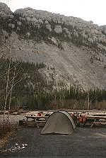
Perfect weather, splendid humour, excellent place for the night. And of course
the anticipated joy for the Cassiar Highway. Finally back to
quiteness, silence and loneliness. Because that's - it's the 2nd of may only -
what I'll be finding out there.
Cassiar Highway
from: Kitwanga
to: Junction 37
distance: 746km
paved all the way (except of 3 spots)
services: Km 145, Km 169 (Meziadin Jct.),
... Km 265 (Bell II), Km 310, Km 370 (Wilson Ridge Resort),
... Km 425 (Iskut), Km 510 (Dease Lake)
easy cycling
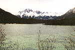
... then do you stand on top - packed in sweater, two jackets, two
trousers and winter gloves, an arctic wind on your face, and happy as a
kid. A fantastic view on surrounding mountains; a river deep down
in the valley; a murmurous creek beside you. Beside that nothing else
than silence. Just silence. Ten minutes of silent enjoyment.
Than is the whiz of the wheels to be heard again.
Is a grandiose land.
|
|
|
|
|
At the end of the Cassiar Highway awaits you
the Yukon Territory
and the famous Alaska Highway.
The Alaska Highway - a dream for most cyclists.
Me myself though, I don't get warm with it. Meanwhile extensively upgraded to
a major highway and overrun by lots of tourists isn't much left of its "flair",
its unique character as a narrow and winding gravel- and asphalt road into the
north.
For this reason did I turn off right away and cycled the Campbell
Highway.
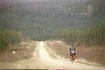
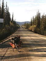
Campbell Highway
from: Watson Lake
to: Carmacks
distance: 588km
completely gravel
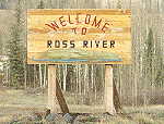
services: Km 362 (Ross River); 10km off
... Km 414 (Faro); 10km off
not easy
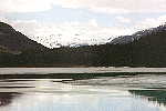
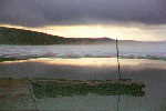
Stand in an open shelter, lookin' past trees and bushes out on the lake.
Wind came up. Small waves grace the previously smooth lake. From the side
do I get warmed by the cast-iron stove I kindled.
Hear a bird landing somewhere out on the lake. Starts to call with
a breathtaking beauty. Also to be heard are some toads on the opposite
shore and the occasional crackle
of the fire beside me. A fish gasps for breath every now and then.
Quiteness
What a peaceableness.
Stand there for hours, just lookin' out on the lake, listening.
The clouds are gone. Through the dark branches of some trees gets a
shiny crescent reflected in the by veils of mist charmed lake. Only
the croaking of the toads is still to be heard.
As the bird with the beautiful calling starts again do I get an expression
on my face that doesn't exist anymore. Perfect hamony and satisfaction.
|
|
|
|
|
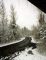
There's beautiful scenery from Carmacks to the turn-off of the Dempster Hwy.
But because it's a paved road and you can get food regularly (approx. every 100km)
will I not enter into.
It's a nice route to let it run though. Cosy, leisurely, interesting.
Dempster Highway
This word makes the alarm-bells of a lot cyclists ring. Wasn't
that this miserable track somewhere in Canadas far north ? Wasn't that a
700km-long dead end, where you'd have to cycle back the same bloody way you
came ?
Yup.
While a lot cyclists don't encounter problems, did the stories of the others
help the Dempster Highway to its reputation as one of the most adventurous
roads in North America.
Now, what's true about those thrilling stories? Here's my impression:
Excerpt from my short-form diary:
05/29:
I'm at the Klondike River Lodge. As I get told aren't the ferries at the Peel River and
the Mackenzie River in yet. But they shall be in on Friday. (Today is Wednesday).
Because it's nice weather do I continue on. Truly fantastic scenery!! Can't be better.
The road runs along a mountain flank with a superb view down into the valley and on the
opposite Ogilvie Mountains! Cycle as far as the Tombstone CG. 72km. But the longer I cycle
the tougher it gets. I'm absolutely burned out when I arrive. Even the marvellous scenery
can't change that. It's midnight. Or probably one or two o'clock. Pitch up my tent,
cook a big load of noodles, and go to bed. Now do I have a short look at the watch.
Half past two. Still broad daylight outside.
05/30:
Wake up at 8. Have a hot milk, then turn around. Too cold, too tired. 10 o'clock. O.k.,
lets get up. Good breakfast has to be after the long distance yesterday. Despite of it are
the joints still sleeping.
 They just don't want as I want. Laboriously up the pass. But also after the pass
- downhill for a long long time - doesn't it become better. At least, it goes on.
My whole body works like someone has pulled the hand-brake. Some time decession:
o.k., lets try it relaxing. And it works. I rather become
slower than faster, but the cycling gets more efficient. By the way, the first
time ever did I cook during a daily trip. No bad experience at all! Another
big meal then in the evening on the Engineer Creek CG. Noodles, tea, coffee,
sandwiches. Will hopefully make the cycling tomorrow easier.
They just don't want as I want. Laboriously up the pass. But also after the pass
- downhill for a long long time - doesn't it become better. At least, it goes on.
My whole body works like someone has pulled the hand-brake. Some time decession:
o.k., lets try it relaxing. And it works. I rather become
slower than faster, but the cycling gets more efficient. By the way, the first
time ever did I cook during a daily trip. No bad experience at all! Another
big meal then in the evening on the Engineer Creek CG. Noodles, tea, coffee,
sandwiches. Will hopefully make the cycling tomorrow easier.
05/31:
 Still tough but fluent going. Really interesting does it become after km 247. The road
runs uphill for about 9 km and continues on as a ridge-road with splendid views
to the left and to the right. It's a continuous up 'n' down. Despite of all
the hills do I get close to Eagle Plains. At 10pm do I stop and pitch up my tent a
little off the road in a gravel pit.
Still tough but fluent going. Really interesting does it become after km 247. The road
runs uphill for about 9 km and continues on as a ridge-road with splendid views
to the left and to the right. It's a continuous up 'n' down. Despite of all
the hills do I get close to Eagle Plains. At 10pm do I stop and pitch up my tent a
little off the road in a gravel pit.
Has it already been hardly over zero degree the last days does the temperature
now drop rapidly. Just take off the gloves and my fingers become stiff instantly.
Have huge problems to pitch up the tent.
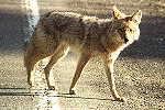
By the way, I saw three bears today. The first between two gravel piles but the noise
I make while stopping makes him disappear. The second one stands eating beside the road.
Whistle, and he heads into the bushes after a short 'registration-pause'. The third one
sees me before I see him and runs down the road about 200m in front of me, stops two times
and turns around to see if I'm still behind him, then finally turns off the road and
disappears between bushes too. All of 'em have been black bears.
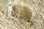
What else? Birds and white grouses. Saw lots of hares on the CG. But also my fist snow-hare today! And
not to forget the squirrels. They live even up here in the north.
06/02:
In Eagle Plains. Stay because the ferrys still aren't in. Have a nice little party
with Gordo, the cook and the "apprentice".
06/03:
Read a lot and listen to CDs.
06/04:
 Superb weather. Breakfast at 10am. Another load of toast at 11am. Head off at noon.
Steep down to the Eagle River. After that generally level, just up 'n' down smaller
hills. Slip through two heavy thunderstorms. Arctic Circle. Scenery unique.
Plains, bounded to the right by the slightly snowcovered Richardson Mountains.
Beautiful sight. Especially because different parts of it become vanished from time
to time by heavy rain- and hale-showers.
Superb weather. Breakfast at 10am. Another load of toast at 11am. Head off at noon.
Steep down to the Eagle River. After that generally level, just up 'n' down smaller
hills. Slip through two heavy thunderstorms. Arctic Circle. Scenery unique.
Plains, bounded to the right by the slightly snowcovered Richardson Mountains.
Beautiful sight. Especially because different parts of it become vanished from time
to time by heavy rain- and hale-showers.
06/05:
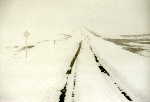
Strenuous day. But saw some beautiful scenery!
Did snow last night. Gordo came in the morning and let me know about the
roadconditions and the ferries. As I head off are 15cm of snow on the road. Only
the tracks of two cars are to be seen. Try to cycle on the
side of the road (marked every few meter by posts) but change into a track after
a while. Because it's (most of the time) easier cycling. Work my way up the pass.
In places 40cm of snow on the road. If I have to change the track or can't keep
me balanced and have to leave my track therefore, do I have to dig myself through
all that snow. Fortunately is it loose snow so that the wheels sink in and my
low watercans get a new functionality as snow-plowers.
 Batteries of the camera are done (too cold), the snowstorm gets stronger (strength
6 or 7), road totally snowed in. Short of the pass do I meet a car of the Yukon
roadmaintenance. "How far is it to the top?" "Almost there." "What does it look like
on the other side?" "A lot of snow and wet." "I'll make it!" Keeps snowing all the
way over the pass. On the other side do I get into some kind of hilly plateau.
The weather clears up and I have a splendid view on the surrounding
mountains. Everything's beautifully snow-white. And then? Have to cycle over
another pass! Pretty steep and even higher than the one before. [At least does it feel
like it!!] Didn't tell me anybody! Though there ain't much snow on the road, is it
extremely wet and soft. Very tough cycling. Also: the air temperature is -5 Celsius
which makes the squirting mud freeze instantly at the bike and cover everything!
Really everything! As soon as I don't use the brakes for a few minutes: frozen;
If I don't shift gears for a while: frozen. Also: the cassette
gets covered by icy mud. Some time do I clean the cassette so that I can use at least
the two biggest sprockets. Works for 10 minutes, then's only the biggest one left.
Though I regularly shift between the 28- and 44-chainring is it normal that
the respectively other becomes frozen and the chain skips the next couple of minutes.
Batteries of the camera are done (too cold), the snowstorm gets stronger (strength
6 or 7), road totally snowed in. Short of the pass do I meet a car of the Yukon
roadmaintenance. "How far is it to the top?" "Almost there." "What does it look like
on the other side?" "A lot of snow and wet." "I'll make it!" Keeps snowing all the
way over the pass. On the other side do I get into some kind of hilly plateau.
The weather clears up and I have a splendid view on the surrounding
mountains. Everything's beautifully snow-white. And then? Have to cycle over
another pass! Pretty steep and even higher than the one before. [At least does it feel
like it!!] Didn't tell me anybody! Though there ain't much snow on the road, is it
extremely wet and soft. Very tough cycling. Also: the air temperature is -5 Celsius
which makes the squirting mud freeze instantly at the bike and cover everything!
Really everything! As soon as I don't use the brakes for a few minutes: frozen;
If I don't shift gears for a while: frozen. Also: the cassette
gets covered by icy mud. Some time do I clean the cassette so that I can use at least
the two biggest sprockets. Works for 10 minutes, then's only the biggest one left.
Though I regularly shift between the 28- and 44-chainring is it normal that
the respectively other becomes frozen and the chain skips the next couple of minutes.
The longer I cycle, the more dirt gets frozen under the fenders, the brakes, etc.
The cycling becomes tougher and tougher. But I really don't wanna spend another 15
minutes again to pick off all the frozen mud with my folk. So keep on cycling
laboriously. Till I see some buildings at Middleway Lake. As I find out are they
left over from a Music Festival in '95. Find a shed that's in a fairly good condition -
and have a 'home' for a night. After a good load of noodles and coffee (the stove also warms up
the shed quite a bit) do I feel better right away. Have another cup of tea as I
write down these words.
Has been a damn hard day. Outside is it -15 deg. Celsius.
06/06:
Wake up at 8 o'clock. Think about to stay in bed and wait for tomorrow. Even in
my shed is it -5 degree. Turn around again. But not for long. Can see a temptingly
shining sun through tiny cracks. Have a good breakfast and get out of my
sleeping bag. Isn't actually as cold as I thought. The sun warms pretty much.
Though not enough to get all my gears going again.
Downhill. Fantastic views in places! Rushing down to the Peel River. Two kilometer
before I get there: big puncture. Not only the tube, the tire has a whole, too! The
ice under der fender, scraping at the tire the day before, used it up as much as
1000km of cycling!! Walk down to the ferry, get over, and change the tire on the CG
on the other side.
Ferry: are still working on the ramp. But already that far that
it can cross over at least every now and then.
Dempster Highway
from: Klondike River Lodge
to: Inuvik
distance: 736km
gravel (except the last 10 km)
services: km 371 (Eagle Plains)
... km 553, km 609
tough cycling
|
INUVIK :
You sit in a cafe, hot chocolate in front of you, study maps. It closes,
you walk back to your tent; read a little bit, get the maps back out again
and ... "it's still daylight outside. What time might it be?" ...
A glance at the watch tells you ... 3 o'clock at night.
Three o'clock and a shining sun.
|
|


